Databases
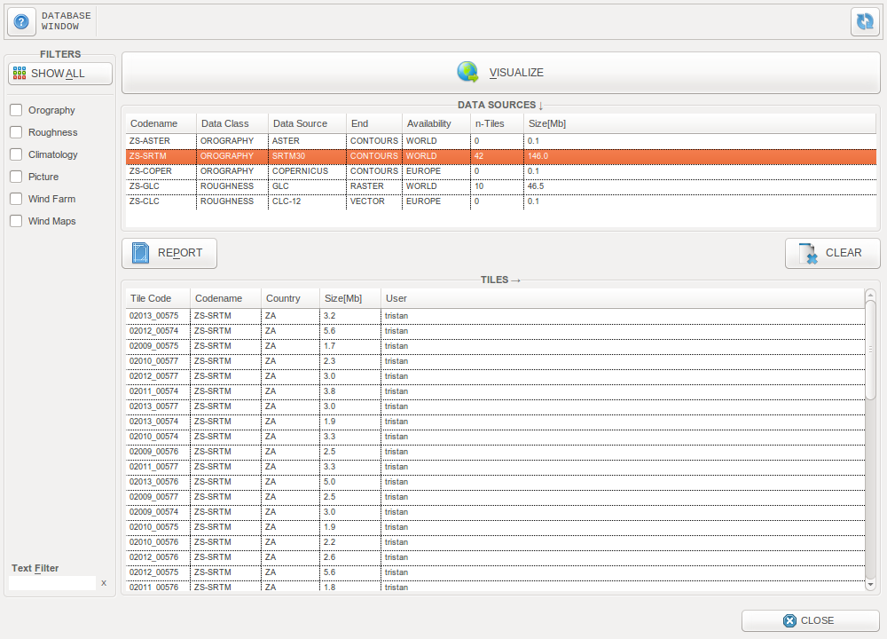
The Databases window
ZephyTOOLS gives access to several public databases, making it possible to automatically download and prepare the topographical data needed as input to any CFD wind farm modeling project.
From this window it is possible to visualize the data from each available database, and to manage the tiles which were downloaded.
Next to each database the user can see how many tiles have been downloaded, and how much disk space they occupy. Eventually, it is possible to clear a database of its downloaded tiles in order to free some disk space.
Note
This window is only meant to visualize the databases, and to manage disk space. To use the databases in CFD projects, just choose a georeference and a database when creating a new project (cf. Project definition).
Data Visualization
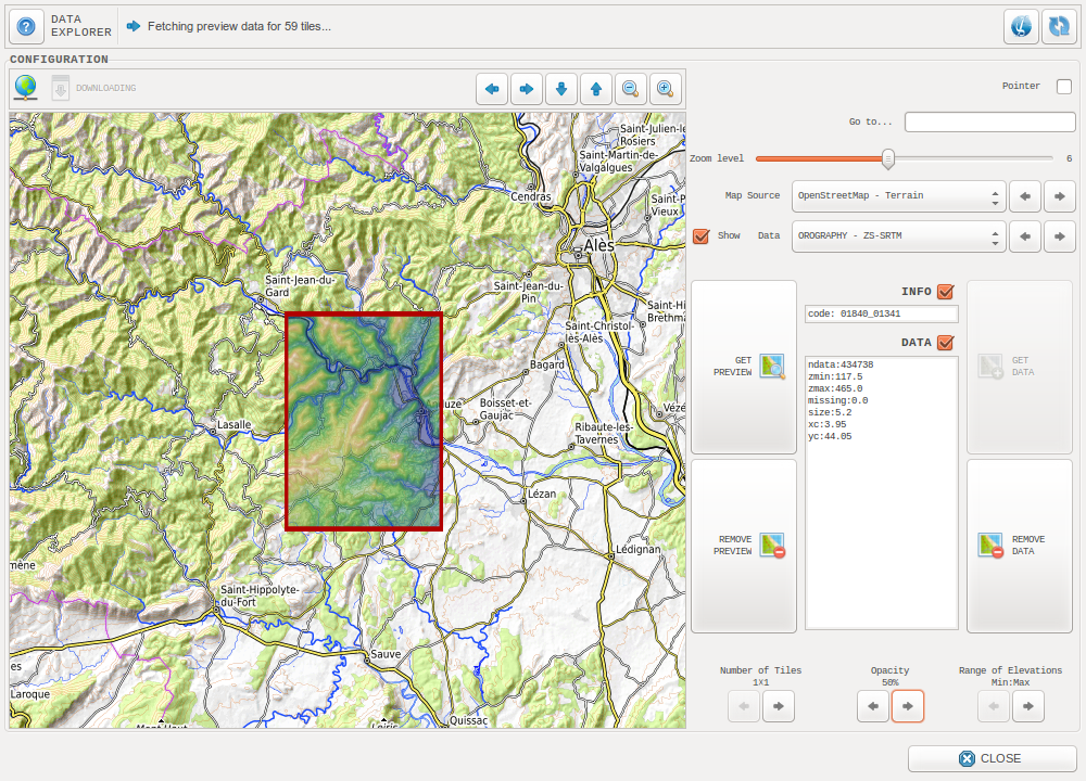
The Databases visualization window
This window revolves around an interactive map, in which the data will be displayed on top of one of the available open-source maps (OpenStreetMap, Bing, Stamen…).
To visualize the data, it is possible to download previews of the data tiles closest to the center of the displayed map, using the GET PREVIEW button. Remove it with the REMOVE PREVIEW button. Like in other ZephyTOOLS visualizations, the map can be dragged by holding the left click.
It is also possible to directly download the complete data from a tile, using the GET DATA button on the right, and to delete it with the REMOVE DATA button.
To process more than one tile at a time, use the right arrow in the bottom-left of the window. It is possible to go up to 7x7 tiles at a time.
The other left/right arrows allow to adjust the data opacity and range.
Orography
ASTER
| Database name | Data Class | Original resolution | Availability | Source |
|---|---|---|---|---|
| ASTER Global Digital Elevation Map, version 3 | Orography | 1 arc-second (~30m) | World | astgtm_v003 |
The Advanced Spaceborne Thermal Emission and Reflection Radiometer (ASTER) Global Digital Elevation Model (GDEM) was developed jointly by the U.S. National Aeronautics and Space Administration (NASA) and Japan’s Ministry of Economy, Trade, and Industry (METI).
In ZephyTOOLS, ZS-ASTER corresponds to the ASTGTM (v003) dataset, which was released on August 5, 2019.
Note
From gisgeography.com:
ASTER GDEM used stereoscopic pairs and digital image correlation methods. Based on two images at different angles, it used stereopairs and photogrammetry to measure elevation. However, the amount of cloud cover affected the accuracy of ASTER which wasn’t the case for SRTM DEM. Because of how passive and active sensors work, this had the most significant effect on quality of DEM.
But over time, ASTER DEM data has improved its products with artifact corrections of their own. In October 2011, ASTER GDEM version 2 was publicly released, which was a considerable improvement.
Despite its experimental grade, ASTER GDEM-2 is considered a more accurate representation than the SRTM elevation model in rugged mountainous terrain.
SRTM
| Database name | Data Class | Original resolution | Availability | Source |
|---|---|---|---|---|
| Space Shuttle Radar Topography Mission (SRTM) | Orography | 1 arc-second (~30m) | World | srtmgl1_v003 |
The Shuttle Radar Topography Mission (SRTM) was flown aboard the space shuttle Endeavour February 11-22, 2000. The National Aeronautics and Space Administration (NASA) and the National Geospatial-Intelligence Agency (NGA) participated in an international project to acquire radar data which were used to create the first near-global set of land elevations.
In ZephyTOOLS, ZS-SRTM corresponds to the SRTMGL1 (v003) dataset, which was released in September 2014.
Note
From gisgeography.com:
Using two radar antennas and a single pass, it [SRTM] collected sufficient data to generate a digital elevation model using a technique known as interferometric synthetic aperture radar (inSAR). C-Band penetrated canopy cover to the ground better but SRTM still struggled in sloping regions with foreshortening, layover and shadow.
In late 2014, the United States government released the highest resolution SRTM DEM to the public. This 1-arc second global digital elevation model has a spatial resolution of about 30 meters. Also, it covers most of the world with absolute vertical height accuracy of less than 16m.
Roughness
FROM-GLC
| Database name | Data Class | Original resolution | Availability | Source |
|---|---|---|---|---|
| Finer Resolution Observation and Monitoring of Global Land Cover (FROM-GLC), 2015 | Roughness | 30m | World | from-glc |
FROM-GLC is a 30m resolution global land cover model produced using Earth observing sensors from the Landsat programmme, Thematic Mapper (TM) and Enhanced Thematic Mapper Plus (ETM+). It was developed at the Earth System Science department of Tsinghua University [1], using four different classification algorithms: conventional maximum likelihood classifier (MLC), J4.8 decision tree classifier, Random Forest (RF) classifier and support vector machine (SVM) classifier.
A total of 38,664 test samples were used for validation, in which The SVM produced the highest overall classification accuracy (OCA) of 64.9%
In ZephyTOOLS, ZS-GLC17 corresponds to the FROM-GLC (2017v0.1.3) dataset, while ZS-GLC15 corresponds to the FROM-GLC (2015_v1) dataset.
| [1] | https://www.tandfonline.com/doi/abs/10.1080/01431161.2012.748992 |